
West Bengal’s industrial spine runs northwest from Kolkata through the Damodar Valley — the coal-mining towns of Durgapur, Asansol, and Raniganj that powered India’s steel and heavy manufacturing economy for much of the post-Independence period. The road connecting Kolkata to this industrial belt has for decades been one of the busiest and most commercially significant highways in eastern India. The Durgapur Expressway is that road — a stretch of NH-19 (the historic Delhi-Kolkata highway, formerly NH-2) connecting Dankuni near Kolkata to Palsit and beyond toward Panagarh, covering the 65-kilometre access-controlled Dankuni-Palsit section that functions as the expressway’s core stretch.
The 65-kilometre Dankuni-Palsit stretch on what was formerly NH-2 is formally known as the Durgapur Expressway. From Palsit to the outskirts of Asansol, it follows the old Grand Trunk Road, bypassing towns such as Saktigarh, Bardhaman, and Raniganj while passing through Durgapur and Andal. The expressway forms part of the Golden Quadrilateral — India’s diamond-shaped high-speed road network connecting Delhi, Mumbai, Chennai, and Kolkata — and sits on the Asian Highway 1 (AH1) corridor.
The highway is now in the midst of its most significant upgrade in two decades. Six-laning work from Dankuni to Panagarh covering 134 kilometres was launched in 2022 at a cost of approximately ₹5,000 crore, with an original completion target of September 2024. The project faced delays due to protests from local residents demanding additional underpasses, flyovers, lifts, and footbridges, with land encroachment issues adding further complexity. As of mid-2025, work is progressing through multiple packages with completion now expected through the year.
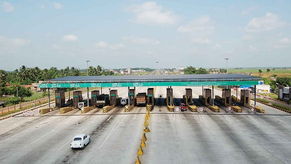
Three toll plazas manage the West Bengal section of NH-19: Durgapur, Palsit, and Dankuni — the three revenue points on a stretch that the NHAI’s 2008 statistical records showed handling 850,000 to 900,000 vehicles daily between Barakar and Dankuni with gross toll collection of ₹2.5 million per day.
Durgapur Expressway Overview
| Detail | Information |
| Name | Durgapur Expressway |
| Highway | NH-19 (formerly NH-2); Part of AH-1, Golden Quadrilateral |
| Core Stretch | Dankuni to Palsit — 65 km (access-controlled expressway section) |
| Extended Stretch | Dankuni to Panagarh — 134 km (under 6-laning upgrade) |
| From | Dankuni, Hooghly District (near Kolkata) |
| To | Panagarh, Paschim Bardhaman District |
| Maintained By | NHAI |
| Six-Laning Project Cost | Approx. ₹5,000 crore |
| Six-Laning Status | Work in progress (started 2022; delayed from original Sept 2024 target) |
| Toll Plazas | Dankuni, Palsit, Durgapur |
| Daily Traffic | 850,000–900,000 vehicles (Barakar-Dankuni section, per NHAI data) |
| Districts Covered | Hooghly, Paschim Bardhaman |
| Key Cities | Kolkata, Dankuni, Bardhaman, Durgapur, Asansol |
| Connects To | NH-16 (Chennai-Kolkata) at Dankuni; NH-19 toward Varanasi/Delhi |
| Golden Quadrilateral | Yes — forms part of Delhi-Kolkata corridor |
Route and Location
The expressway starts at Dankuni — Kolkata’s western industrial township at the confluence of NH-19 and NH-16 — and runs northwestward through Hooghly and Bardhaman districts. Dankuni itself is one of West Bengal’s most important transit hubs, where the Belghoria Expressway connects toward North Kolkata and NH-16 diverges toward Chennai. The expressway passes through Singur in Hooghly — the township that became a defining location in India’s land acquisition debate due to the Tata Nano project controversy.
Connectivity
The Dankuni junction connects the Durgapur Expressway to NH-16 (Chennai-Kolkata coastal highway), the Belghoria Expressway into Kolkata’s northern suburbs, and onward to NH-19 toward Bihar, Jharkhand, and Delhi. At Panagarh, the Panagarh-Morgram Highway branches northward toward Suri and Siliguri, making Panagarh a crucial branching point for traffic heading to North Bengal and the northeast.
Nearby Areas
Durgapur Steel Plant: One of India’s major public sector steel plants, established in 1956 in collaboration with the British government, is the defining industrial landmark of the Durgapur zone accessible from the expressway. Bardhaman: The historically significant district headquarters of Paschim Bardhaman — with its Curzon Gate, Vijay Toran arch, and cultural institutions — lies along the expressway corridor. Mukutmanipur: The scenic reservoir and dam in Bankura district is accessible from the expressway zone via connecting roads.
Frequently Asked Questions (FAQs)
Q1. What is the Durgapur Expressway?
A: The 65-km access-controlled section of NH-19 (formerly NH-2, the Delhi-Kolkata highway) between Dankuni and Palsit in West Bengal — part of India’s Golden Quadrilateral.
Q2. What upgrade is happening on the Durgapur Expressway?
A: Six-laning of the 134 km Dankuni-to-Panagarh stretch at approximately ₹5,000 crore. Work started in 2022 and is in progress, delayed from its original September 2024 target.
Q3. How many vehicles use the Durgapur Expressway daily?
A: NHAI data records 850,000 to 900,000 vehicles daily between Barakar and Dankuni.
Q4. Which toll plazas are on the Durgapur Expressway?
A: Three in West Bengal — Dankuni, Palsit, and Durgapur.
Q5. What other highways connect at Dankuni?
A: NH-16 (Chennai-Kolkata), the Belghoria Expressway, and NH-19 onward toward Bihar and Delhi all converge at Dankuni.