
When Hyderabad’s new international airport opened at Shamshabad in 2008, the city realised quickly that building the airport was the easier part. Getting people there from the western commercial heart of the city was a different problem entirely. Three roads connected Mehdipatnam to Shamshabad — one was perpetually congested, one cut through narrow older city streets, and the third was inaccessible to most of the western residential belt. The solution arrived a year later, elevated above all three problems.
The PV Narasimha Rao Expressway — named after the former Prime Minister who was born in the Telangana region — is an 11.6-kilometre elevated corridor that lifts traffic above Hyderabad’s southwestern road network and delivers it to NH-44 near Aramgarh junction, from where the airport is a straightforward drive. Inaugurated in October 2009 at a project cost of approximately ₹600 crore, it held the distinction of being India’s longest continuous elevated road structure at the time of opening. That record has since been surpassed, but the expressway’s practical contribution to the city’s airport connectivity remains as relevant today as it was when it first opened.
The expressway is fully operational and managed by the Hyderabad Metropolitan Development Authority. Entry for two-wheelers, three-wheelers, autorickshaws, and goods vehicles is prohibited — this is a car and bus corridor, and that restriction is enforced. The three sharp turns at Laxminagar, Upparpally, and Shivrampally narrow the carriageway and carry their own lower speed restriction, which the traffic police monitor actively.
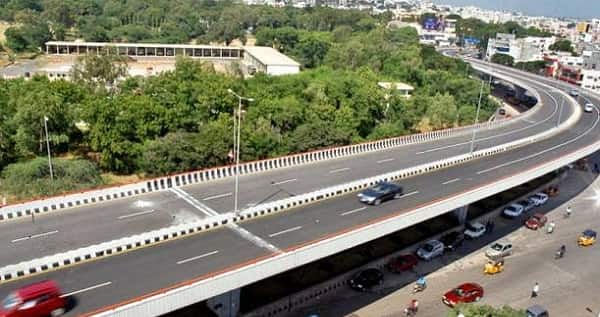
PV Narasimha Rao Expressway Overview
| Detail | Information |
| Full Name | P.V. Narasimha Rao Elevated Expressway (PVNR Expressway) |
| Current Status | Fully Operational since October 2009 |
| Location | Mehdipatnam to Aramgarh Junction, Hyderabad, Telangana |
| Route | Sarojini Devi Eye Hospital, Mehdipatnam → Aramgarh Junction, NH-44 |
| Key Areas Passed | Rethibowli, Laxminagar, Attapur, Hyderguda, Upperpally, Rajendra Nagar |
| Total Length | 11.6 km |
| Lanes | 4 lanes (divided carriageway) |
| Speed Limit | 60 km/h (general); 40 km/h at sharp turns |
| Toll Fee | Toll-Free (proposals discussed but not yet implemented) |
| Prohibited Vehicles | Two-wheelers, three-wheelers, autorickshaws, goods vehicles |
| Ramps | 3 sets of entry and exit ramps (Up and Down) |
| Governing Authority | Hyderabad Metropolitan Development Authority (HMDA) |
| Project Cost | Approx. ₹600 crore |
| Nearest Metro | Mehdipatnam — Hyderabad Metro Blue Line |
| Airport Connected | Rajiv Gandhi International Airport, Shamshabad |
Route and Location
The expressway begins at the Sarojini Devi Eye Hospital junction in Mehdipatnam — one of Hyderabad’s busiest western commercial intersections — and runs elevated through Rethibowli, Laxminagar, Attapur, Hyderguda, Upperpally, and Rajendra Nagar before descending at the Aramgarh junction on NH-44. From Aramgarh, the airport is approximately 10 kilometres further south along the national highway.
The elevated alignment was chosen specifically to avoid the ground-level complexity of these densely populated localities. The carriageway maintains two lanes in each direction across most of its length, narrowing temporarily to one and a half lanes at the three sharp-turn sections where speed restrictions apply.
Speed Limits
The general speed limit of 60 km/h for light motor vehicles applies across most of the expressway’s length. At the three sharp-turn sections — Laxminagar, Upparpally, and Shivrampally — the limit drops to 40 km/h where the carriageway narrows. Overtaking is strictly prohibited at these narrow sections, and parking anywhere on the elevated structure is banned entirely.
Toll Fee
The PVNR Expressway currently operates toll-free for users. Proposals to introduce toll collection have been discussed periodically by HMDA over the years, but as of May 2026, no toll has been implemented on this corridor. This makes it one of the few operational expressways in India’s major metropolitan areas that remains free to use.
Nearby Areas
Mehdipatnam: The bustling commercial zone at the expressway’s northern entry is one of Hyderabad’s most important bus and commercial hubs, making the elevated start point genuinely useful for the large population of this commercial belt. Rajendra Nagar: The large residential colony accessible from the mid-expressway ramps benefits directly from the elevated corridor’s faster connectivity toward both the city center and the airport direction. Shamshabad and Airport Zone: The Rajiv Gandhi International Airport — India’s sixth busiest — is the ultimate destination the expressway serves, and the 20-minute journey it now enables replaced what used to be a 60-plus minute ordeal through congested surface roads.
Frequently Asked Questions (FAQs)
Q1. What is the PVNR Expressway and where is it located?
A: An 11.6 km elevated expressway in Hyderabad connecting Mehdipatnam to Aramgarh Junction on NH-44, providing faster access to Rajiv Gandhi International Airport.
Q2. Is the PVNR Expressway toll-free?
A: Yes, currently toll-free. Toll proposals have been discussed but not implemented as of 2026.
Q3. What vehicles are prohibited on PVNR Expressway?
A: Two-wheelers, three-wheelers, autorickshaws, and goods vehicles are not permitted.
Q4. What is the speed limit on PVNR Expressway?
A: 60 km/h generally; reduced to 40 km/h at the three sharp-turn sections at Laxminagar, Upparpally, and Shivrampally.
Q5. How much time does PVNR Expressway save for airport travel?
A: It reduces the Mehdipatnam to airport journey from over an hour to approximately 20 minutes under normal traffic conditions.