West Bengal’s road infrastructure story has often been overshadowed by the state’s more celebrated achievements in culture, education, and urban architecture. But the Kalyani Expressway — connecting Kolkata’s northern urban boundary to the planned industrial township of Kalyani in Nadia district — is a piece of road infrastructure that deserves genuine recognition on its own terms. It is one of the older expressway-standard roads in eastern India, predating the national expressway building wave of the 2010s and 2020s, and it serves a corridor of considerable economic and demographic importance for West Bengal’s industrial and residential geography.
Kalyani itself is not a casual destination. Planned in the 1950s as a model township along lines inspired by the idealism of India’s early post-independence urban planning thinking, it grew into one of West Bengal’s most significant industrial and academic centers — home to the University of Kalyani, the Central Glass and Ceramic Research Institute, and numerous manufacturing and pharmaceutical units that make it a productive node in the state’s industrial economy. The expressway connecting it to Kolkata serves the daily commuting needs of thousands of industrial workers, academic staff, students, and business travelers who move between these two points regularly. For anyone traveling between Kolkata and the Nadia-Murshidabad belt, or heading further north toward North Bengal, the Kalyani Expressway is the natural and fastest starting point for that journey northward out of the metropolis.
Kalyani Expressway, West Bengal – Quick Overview
|
Detail |
Information |
|
Full Name |
Kalyani Expressway |
|
Also Known As |
B.T. Road Expressway / Kalyani Expressway Road |
|
Total Length |
Approx. 50 km |
|
States Covered |
West Bengal |
|
Starting Point |
Dunlop Bridge / Chiria More, North Kolkata |
|
Ending Point |
Kalyani, Nadia District, West Bengal |
|
Highway Classification |
State Highway — SH-2 / NH-12 Feeder |
|
Number of Lanes |
4 to 6 lanes across different sections |
|
Speed Limit |
80 km/h for cars; 60 km/h for heavy vehicles |
|
Toll Collection |
Toll plaza at Kalyani end; cash and FASTag |
|
Car Toll Fee (One Way) |
Approx. ₹40–₹60 |
|
Heavy Vehicle Toll |
Approx. ₹120–₹200 depending on vehicle category |
|
Governing Authority |
West Bengal PWD, WBHIDCO |
|
Passes Through |
Dunlop, Barrackpore, Halisahar, Kalyani |
|
Unique Feature |
One of eastern India’s earliest expressway-standard roads |
Route and Location
The Kalyani Expressway begins at the Dunlop Bridge and Chiria More intersection in North Kolkata — one of the city’s most important northern transit nodes where multiple arterial roads, bus routes, and local rail lines converge — and heads northward through the densely populated industrial and residential belt that lines the western bank of the Hooghly River all the way to Kalyani in Nadia district.
Leaving Kolkata’s northern boundary, the expressway passes through Barrackpore — one of the most historically significant military cantonments in colonial India and today a substantial urban agglomeration in North 24 Parganas district. Barrackpore’s riverside setting, its Gandhi Ghat, and its numerous working-class residential colonies make it one of the most densely populated stretches along the entire expressway route. Continuing northward, the road passes through Halisahar and Naihati — two industrial towns that house significant jute processing, chemical manufacturing, and small-scale engineering units — before crossing into Nadia district and approaching Kalyani.
Kalyani’s planned grid layout means the expressway enters the township through a well-designed approach road that contrasts noticeably with the organic urban sprawl of the Barrackpore corridor. The township’s wide internal roads, institutional campuses, and green buffer zones reflect its planned origin and give the northern terminus of the expressway a distinctly different character from its southern starting point in Kolkata’s dense northern industrial fringe.
The expressway broadly follows the historic B.T. Road alignment — a road whose full name, Barrackpore Trunk Road, reflects its colonial-era origin as the primary military and administrative road connecting Calcutta’s Fort William to the Barrackpore cantonment where the British Indian Army’s Bengal regiments were stationed. This historical layer gives the road a narrative depth that newer greenfield expressways in other states simply do not possess.
Length and Road Specifications
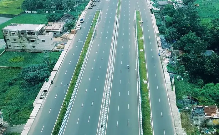
At approximately 50 kilometres, the Kalyani Expressway is one of the shorter expressway-standard roads in India, but its importance to West Bengal’s northern connectivity is disproportionate to its length. The road varies between four and six lanes across different sections, with the Kolkata-proximate stretches carrying the higher lane counts to manage the denser urban traffic volumes of the Barrackpore industrial belt.
Unlike the fully access-controlled greenfield expressways built in Uttar Pradesh, Gujarat, and Haryana, the Kalyani Expressway is a more urban arterial road that has been upgraded to expressway standards over time. This means some sections retain characteristics of a high-quality urban arterial rather than a pure controlled-access highway, with certain service road arrangements and intersection configurations reflecting the road’s evolutionary development rather than a single greenfield design. Road improvement and widening work has been undertaken periodically by West Bengal PWD to keep the corridor’s capacity aligned with growing traffic volumes.
Speed Limit
The Kalyani Expressway carries an 80 kilometre per hour maximum speed limit for private cars — lower than the 100 to 120 km/h limits seen on newer greenfield expressways in other states, reflecting the road’s more urban character and the higher density of access points, residential areas, and cross-traffic in the Barrackpore belt. Heavy commercial vehicles are restricted to 60 km/h throughout. Speed enforcement is managed by West Bengal traffic police through patrol vehicles and camera monitoring, with enforcement particularly active around the Barrackpore and Halisahar sections where pedestrian and local vehicle activity increases the risk profile.
Kalyani Expressway, West Bengal: Toll Fee
Tolling on the Kalyani Expressway is relatively modest compared to the longer expressways of western and northern India, reflecting both the road’s shorter length and its state highway classification. The primary toll collection point is located at the Kalyani end of the expressway. For private cars, the one-way toll is approximately ₹40 to ₹60, making it one of the more affordable tolled roads in eastern India. Heavy commercial vehicles pay approximately ₹120 to ₹200 depending on vehicle category and axle configuration. Both cash and FASTag payment modes are accepted at the Kalyani toll plaza, reflecting the road’s older toll infrastructure that has not yet been fully converted to the FASTag-only model adopted on newer NHAI expressways.
Frequently Asked Questions (FAQs)
Q1. What is the total length of the Kalyani Expressway in West Bengal?
The Kalyani Expressway is approximately 50 kilometres long, running from Dunlop Bridge in North Kolkata to Kalyani in Nadia district.
Q2. What is the speed limit on the Kalyani Expressway?
Cars can travel at up to 80 km/h while heavy vehicles are restricted to 60 km/h throughout the expressway.
Q3. How much is the toll for a car on the Kalyani Expressway?
The one-way toll for a private car is approximately ₹40 to ₹60 at the Kalyani toll plaza.
Q4. Which major areas does the Kalyani Expressway pass through?
The expressway passes through Dunlop, Barrackpore, Halisahar, and Naihati before reaching Kalyani in Nadia district.
Q5. Is FASTag accepted on the Kalyani Expressway?
Yes, FASTag is accepted alongside cash at the Kalyani toll plaza, though the full FASTag-only transition is still evolving on this older corridor.