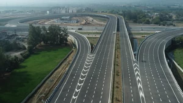
Scale, ambition, and corridor-length records are nothing new to India’s expressway programme. But the Delhi-Mumbai Expressway — formally National Expressway 4 (NE-4) — eclipses every previous record by a margin that makes the comparison almost unfair. At 1,386 kilometres, it is not merely the longest expressway in India but nearly twice the length of the country’s second-longest. It passes through six states. It reduces the travel time between the national capital and the country’s financial capital from 24 hours to 12. It features an 8-lane access-controlled design with provisions for expansion to 12 lanes. It is, in the language of India’s infrastructure ambition, the most consequential road project since the Golden Quadrilateral.
The Delhi-Mumbai Expressway is recognised as the longest expressway in India as of 2025, spanning 1,386 kilometres and featuring an 8-lane design with future expansion capacity up to 12 lanes. As of 2025, India has over 6,000 km of operational expressways, with 11,127 km under construction. The expressway passes through Delhi, Haryana, Rajasthan, Madhya Pradesh, Gujarat, and Maharashtra — the six-state corridor connecting the national capital to the country’s commercial capital via the desert, plateau, and coastal plain geographies that define India’s western interior.
Sections of the expressway have been progressively opening since February 2023. The Yamuna Expressway serves as a parallel Delhi-Agra route on the eastern side, while the Delhi-Mumbai Expressway provides the western interior corridor. The project is developed by NHAI under the Bharatmala Pariyojana’s core economic corridor programme and is designed with modern features including wildlife corridors, animal underpasses, smart traffic management systems, and eco-friendly construction practices.
Longest Expressway Overview
| Detail | Information |
| Official Name | Delhi-Mumbai Expressway (National Expressway 4 / NE-4) |
| Maintained By | National Highways Authority of India (NHAI) |
| Length | 1,386 km (longest expressway in India) |
| Lanes | 8-lane access-controlled (expandable to 12) |
| North End | DND Flyway, Delhi / Sohna Elevated Corridor, Haryana |
| South End | JNPT, Mumbai MMR / Virar, Mumbai MMR |
| Design Speed | 120 km/h |
| Travel Time (Delhi-Mumbai) | ~12 hours (down from 24 hours on NH-48) |
| States Covered | Delhi, Haryana, Rajasthan, Madhya Pradesh, Gujarat, Maharashtra |
| Programme | Bharatmala Pariyojana — Core Economic Corridor |
| Key Cities | Delhi, Gurgaon, Faridabad, Alwar, Dausa, Sawai Madhopur, Kota, Ratlam, Vadodara, Surat, Vapi, Mumbai |
| Sections Open (as of 2025) | Delhi-Jaipur; Dausa-Sawai Madhopur; Kota-Laban; Vadodara-Bharuch; Bharuch-Kharel; Vadodara-Godhra |
| Key Spurs | Jaipur Spur (67 km); Noida-Jewar Airport Spur (30 km); Ujjain Spur (130 km) |
| Distance Reduction | ~150 km shorter than existing NH-48 route |
| Distinctive Features | Wildlife corridors; animal underpasses; smart traffic management; eco-friendly construction |
| Rank | Longest in India; among longest in Asia |
Route and Location
The expressway begins at Delhi’s DND Flyway junction and runs southwestward through Haryana’s Gurgaon-Faridabad industrial belt, then enters Rajasthan’s Aravalli foothills before crossing the Rajasthan desert through Dausa, Sawai Madhopur, and Kota. It enters Madhya Pradesh and traverses the Malwa Plateau via Ratlam before entering Gujarat at Dahod, continuing through Vadodara, Bharuch, and the Surat industrial corridor before entering Maharashtra and reaching Mumbai’s JNPT port complex at one terminal and Virar at the other.
Connectivity
The expressway connects several major spurs: the 67-kilometre Jaipur Spur links Bandikui to Jaipur, giving Rajasthan’s capital direct expressway access. The 30-kilometre Jewar Airport Spur connects to Noida’s new international airport. The 130-kilometre Ujjain Spur in Madhya Pradesh serves the sacred Ujjain pilgrimage city. At Mumbai, it connects to JNPT — India’s largest container port — making this simultaneously a passenger highway and a port logistics backbone.
Nearby Areas
Ranthambore National Park: The celebrated tiger reserve in Rajasthan’s Sawai Madhopur district is accessible from the expressway’s Rajasthan section — the wildlife corridors designed into the expressway specifically acknowledge the ecological sensitivity of this zone. Udaipur: The Lake City is accessible via Rajasthan’s connecting roads from the expressway zone. Vadodara: The historic Gaekwad capital and major industrial city anchors the Gujarat section of the expressway.
Frequently Asked Questions (FAQs)
Q1. What is the longest expressway in India?
A: The Delhi-Mumbai Expressway (NE-4) — 1,386 km, eight-lane, passing through six states. Longest in India and among the longest access-controlled highways in Asia.
Q2. How much time does the Delhi-Mumbai Expressway save?
A: It reduces Delhi-to-Mumbai travel time from approximately 24 hours to 12 hours, and the distance by approximately 150 km compared to the existing NH-48 route.
Q3. Which states does India’s longest expressway pass through?
A: Six — Delhi, Haryana, Rajasthan, Madhya Pradesh, Gujarat, and Maharashtra.
Q4. Is the Delhi-Mumbai Expressway fully open?
A: Multiple sections have been progressively opening since February 2023. Several major sections are operational, with remaining packages completing through 2025-26.
Q5. What makes the Delhi-Mumbai Expressway environmentally distinctive?
A: It includes dedicated wildlife corridors and animal underpasses to allow safe crossing for wildlife in ecologically sensitive zones, particularly around Ranthambore in Rajasthan.