
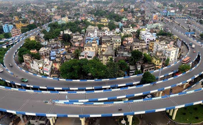
Kolkata’s relationship with its road infrastructure has always been complicated. The city grew organically along the Hooghly River over three centuries, accumulating the kind of layered urban complexity that makes building new road corridors genuinely difficult without displacing something historically or socially significant. The Kona Expressway is one of the more successful attempts to cut through this complexity — a road that connects the National Highway network at the city’s southwestern entry point to the heart of Kolkata’s road system without the kind of surface-level congestion that makes the older arterials a daily test of patience.
The expressway takes its name from the Kona area through which it passes — a locality in Howrah district that serves as the geographic entry point for traffic arriving from the southwest along NH-16 (the old NH-6 heading toward Mumbai and Pune via Kharagpur). Its primary function is transition — it takes the high-speed highway traffic that has traveled from Kharagpur, Bhubaneswar, or Mumbai and delivers it into the Kolkata metropolitan area in a manner that maintains some of the highway momentum rather than immediately surrendering it to the city’s ground-level chaos. For the millions of people and the enormous volume of freight that moves between Kolkata and the western and southern Indian corridor, the Kona Expressway is the first and last stretch of road that carries genuine expressway character on the city’s southwestern approach.
Overview Table
| Detail | Information |
| Location | Kona, Howrah District, West Bengal |
| Route | Kona (NH-16 Junction) to Vidyasagar Setu (Second Hooghly Bridge) |
| Total Length | Approx. 8–10 km |
| Highway Classification | State Expressway / Urban Expressway |
| Starting Point | Kona junction on NH-16, Howrah |
| Ending Point | Vidyasagar Setu approach, Howrah |
| Lanes | 4 lanes (2 in each direction) |
| Speed Limit | 80 km/h (cars); 60 km/h (heavy vehicles) |
| Toll Fee | Approx. ₹25–45 for cars; varies by vehicle category |
| Toll Collection | FASTag-enabled toll plazas |
| Governing Authority | NHAI / WBHIDCO / West Bengal PWD |
| Nearest Railway Station | Santragachi Railway Station — Approx. 3–5 km |
| Key Connections | NH-16 (Mumbai-Kolkata Highway), Vidyasagar Setu, Kolkata city road network |
| Significance | Primary southwestern entry expressway into Kolkata Metropolitan Area |
Route and Location
The Kona Expressway begins at the Kona interchange on NH-16 in Howrah district — the point where the national highway traffic arriving from Kharagpur and the southwestern direction meets the first structured urban approach to Kolkata. From this interchange, the expressway runs northeastward through the Kona, Andul Road, and Domjur belt of Howrah before approaching the Vidyasagar Setu — the Second Hooghly Bridge — whose approach roads deliver the traffic across the river into Kolkata’s Ekbalpore and Alipore zones.
Howrah district surrounds this expressway on both sides for most of its length, and the urban character visible from the road transitions through the journey from the relatively open industrial fringe zones near the Kona interchange to the denser residential and commercial fabric of the inner Howrah belt approaching the bridge. The expressway passes through one of the most industrially significant corridors in the eastern India manufacturing belt — the Howrah industrial zone with its foundries, engineering workshops, and light manufacturing units that have made this district famous in Indian industrial history.
Length and Speed Limits
At approximately 8 to 10 kilometres, the Kona Expressway is compact by national expressway standards — this is not a long-distance highway like the Yamuna Expressway or the Mumbai-Pune corridor, but rather an urban approach expressway whose value lies entirely in the time it saves on what would otherwise be a painfully slow passage through Howrah’s dense road network. The speed limit of 80 km/h for cars and 60 km/h for heavy vehicles reflects the urban expressway designation — higher than the surrounding city roads but lower than the open highway standards of rural expressways.
The 80 km/h limit is aspirational during peak hours, when the approach to the Vidyasagar Setu creates queuing that reduces actual speeds considerably. The expressway’s genuine value is experienced most clearly during off-peak hours — early mornings and late evenings — when the speed limits are actually achievable and the time savings over the surface route are substantial.
Toll Fee
The toll structure for the Kona Expressway is modest relative to longer expressways, reflecting both the short distance and the urban expressway classification. Cars typically pay in the range of ₹25 to ₹45 per passage, with heavier vehicles paying proportionally higher rates based on axle count and vehicle category. FASTag is the primary payment mode, consistent with NHAI’s national policy of converting all toll collection to electronic payment to reduce plaza queuing. Cash lanes remain available but carry the standard additional charge that discourages cash payment in the FASTag era.
Connectivity
The expressway’s two anchor connections define its significance. At the southwestern end, the NH-16 interchange connects it to the entire Mumbai-Kolkata highway corridor stretching southwestward toward Bhubaneswar, Visakhapatnam, and eventually Mumbai. At the northeastern end, the Vidyasagar Setu connection takes the traffic across the Hooghly River into Kolkata proper, from where the city’s internal road network distributes it toward the commercial center, the port, and the northern and southern residential zones of India’s third-largest city.
Nearby Areas
Santragachi: The important Howrah railway junction and its surrounding residential and commercial zone is within the Kona Expressway’s catchment, with residents using the expressway for faster access to the Vidyasagar Setu crossing.
Howrah Industrial Zone: The foundry and engineering belt of Howrah that runs alongside portions of the expressway corridor represents one of India’s oldest and most productive manufacturing districts.
Vidyasagar Setu: The Second Hooghly Bridge whose approach the expressway feeds is one of India’s most important urban river crossings, handling an enormous daily volume of vehicles between Howrah and Kolkata.
Belur Math: The global headquarters of the Ramakrishna Mission founded by Swami Vivekananda is accessible from the expressway zone via the Howrah road network and draws significant religious visitor traffic through this corridor.
Frequently Asked Questions (FAQs)
Q1. What is the Kona Expressway and where is it located?
An urban approach expressway in Howrah, West Bengal, connecting NH-16 at Kona to the Vidyasagar Setu approach — approximately 8 to 10 kilometres long.
Q2. What is the toll fee on Kona Expressway?
Approximately ₹25 to ₹45 for cars, varying by vehicle category. FASTag is the primary payment mode.
Q3. What is the speed limit on Kona Expressway?
80 km/h for cars and 60 km/h for heavy vehicles under normal conditions.
Q4. What highway does the Kona Expressway connect to?
NH-16 (the Mumbai-Kolkata National Highway) at the Kona interchange in Howrah.
Q5. How does the Kona Expressway reduce travel time into Kolkata?
By bypassing Howrah’s congested surface road network through an elevated/expressway corridor delivering traffic directly to the Vidyasagar Setu bridge approach.