
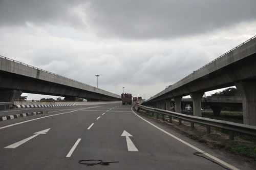
Kolkata’s northern metropolitan sprawl has always been a logistical headache — the concentration of national highways, the port traffic, the airport, and the dense industrial and residential belt of the Howrah-Hooghly corridor all competing for road space through a network that was not designed for the volumes it now carries. The Belghoria Expressway cuts through this complexity with a specificity of purpose that gives it a particular value — it is not trying to be everything to everyone, it is a bypass that does one thing well: linking the national highway junction at Dankuni to the airport zone at Dumdum without routing through the congested core of northern Kolkata.
Originally commissioned in 1967 and progressively upgraded over the following decades, the expressway reached its current operational form in 2008 when it was inaugurated as a fully functional grade-separated corridor. It forms part of the Asian Highway 1 network — the trans-Asian road system that theoretically connects Tokyo to Istanbul — which gives this 16-kilometre stretch a connectivity significance that extends far beyond its modest length. Practically, it serves the daily movement of freight, commuters, and airport-bound travelers through Kolkata’s densely inhabited northern suburbs with the grade-separated efficiency that the at-grade alternatives cannot match.
Overview Table
| Detail | Information |
| Name | Belghoria Expressway |
| Current Status | Fully Operational since 2008 |
| Location | Northern Kolkata Metropolitan Area, West Bengal |
| Route | Rajchandrapur near Dankuni (West) → Jessore Road near NSCBI Airport Gate 3 (East) |
| Key Areas Passed | Belghoria, Baranagar, Dum Dum, Gopalpur, Bally, Manikpur |
| Total Length | 16 km |
| Lanes | 4 to 6 lanes (varies by section) |
| Speed Limit | 80 km/h (general) |
| Toll Fee (Cars) | ₹65 one-way (effective July 4, 2025) |
| Toll — Buses | ₹135 one-way |
| Toll — Light Goods Vehicles | ₹185 one-way |
| Toll — Trucks | ₹320 one-way |
| Toll — Multi-Axle Vehicles | ₹375 one-way |
| Toll Collection | FASTag mandatory since February 2021 |
| Highway Network | Part of Asian Highway 1 (AH1); Connects NH-16 and NH-19 |
| Governing Authority | NHAI |
| Nearest Metro | Baranagar / Dakshineswar — Kolkata Metro |
Route and Location
The Belghoria Expressway runs east to west across the northern metropolitan zone of Kolkata, beginning at the Rajchandrapur junction near Dankuni where NH-16 and NH-19 converge — two of India’s most important national highways — and terminating at Jessore Road near the Netaji Subhas Chandra Bose International Airport’s Gate 3.
The route passes through some of Kolkata’s most densely inhabited northern localities — Belghoria, Baranagar, Manikpur, Dum Dum, Gopalpur, and Bally — traversing both North 24 Parganas district and Howrah district along its 16-kilometre alignment. The grade-separated design means the expressway carries traffic above or past the ground-level congestion of these localities rather than through them, which is precisely the operational advantage it provides over the alternative surface routes.
Speed Limits and Toll Fee
The general speed limit on the Belghoria Expressway is 80 km/h, appropriate for an urban bypass corridor passing through the northern metropolitan zone. Toll rates effective from July 4, 2025 are ₹65 for cars one-way, revised annually using a formula tied to the Wholesale Price Index and Rupee-USD exchange rate as stipulated in the concession agreement. FASTag has been mandatory on this expressway since February 2021. Vehicles without a valid FASTag are required to pay double the toll fee — consistent with NHAI’s national policy on FASTag non-compliance.
Nearby Areas
Dankuni Industrial Zone: The western entry point at Rajchandrapur connects to Dankuni’s important industrial and logistics belt, making the expressway critical for freight movement between the port zone and the highway network. Baranagar and Dum Dum: Two of Kolkata’s most historically significant northern localities lie along the expressway corridor, with residential property prices in the surrounding areas having risen noticeably since the expressway improved connectivity. Dakshineswar and Belur Math: The spiritually significant Dakshineswar Kali Temple and the Ramakrishna Mission’s global headquarters at Belur Math are accessible from the western section of the expressway, adding a religious tourism dimension to the corridor’s daily traffic.
Frequently Asked Questions (FAQs)
Q1. What is the Belghoria Expressway and where is it in Kolkata?
A 16 km grade-separated bypass expressway in northern Kolkata connecting the NH-16/NH-19 junction at Dankuni to Jessore Road near the airport — fully operational since 2008.
Q2. What is the current toll fee on Belghoria Expressway?
₹65 one-way for cars, effective July 4, 2025. FASTag is mandatory; vehicles without it pay double.
Q3. Which national highways does Belghoria Expressway connect?
NH-16 and NH-19 at the Rajchandrapur/Dankuni end, connecting to Jessore Road at the airport end.
Q4. Is Belghoria Expressway part of any international highway network?
Yes — it forms part of Asian Highway 1 (AH1), the trans-Asian road network.
Q5. What is the speed limit on Belghoria Expressway?
80 km/h general speed limit across the expressway corridor.