
The Chennai Bangalore Expressway has had a deadline problem. The 262-kilometre greenfield corridor connecting two of South India’s most economically powerful cities — Bengaluru and Chennai — was originally supposed to open in 2024, then August 2025, and the revised expectation now points toward mid-2026 for full commissioning. None of these delays diminish what this road will eventually mean for the region. A journey that currently takes between five and seven hours depending on which route you take and how cooperative the traffic feels will compress to approximately two and a half hours. That is not a modest improvement — it is a fundamental shift in the practical relationship between these two cities.
The Bangalore Chennai Expressway is a four-lane (expandable to eight-lane) under-construction expressway developed by the National Highways Authority of India (NHAI). Officially designated as National Expressway 7 (NE-7), it runs through three states — Karnataka, Andhra Pradesh, and Tamil Nadu — and passes through the Kolar gold fields zone, the Chittoor district of Andhra Pradesh, and the Vellore and Kanchipuram districts of Tamil Nadu before reaching Sriperumbudur on Chennai’s western outskirts.
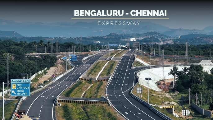
Current Status (as of May 2026): Partially operational. The Karnataka section (71 km) has been open since December 2024. Andhra Pradesh and Tamil Nadu sections remain under construction. Full completion expected mid-2026.
Overview Table
| Detail | Information |
| Official Name | Bengaluru–Chennai Expressway (National Expressway 7 / NE-7) |
| Current Status | Partially Operational — Karnataka section open; AP and TN under construction |
| Karnataka Section Status | Open since December 2024 (71 km, Hoskote to Bethamangala) |
| AP Section Status | Under construction — various packages at 64–86% completion |
| Tamil Nadu Section Status | Under construction — revised completion October 2026 for some packages |
| Full Completion Expected | Mid-2026 (revised from original August 2025) |
| Route | Hoskote, Bengaluru (Karnataka) → Sriperumbudur, Chennai (Tamil Nadu) |
| Total Length | Approx. 262 km |
| States Covered | Karnataka, Andhra Pradesh, Tamil Nadu |
| Lanes | 4 lanes (expandable to 8 by 2041) |
| Speed Limit | 120 km/h (cars); 60 km/h (heavy vehicles) |
| Projected Toll Fee | Approx. ₹150 one-way for cars (Karnataka section) |
| Governing Authority | NHAI (National Highways Authority of India) |
| Project Cost | Approx. ₹18,000 crore |
| Travel Time After Completion | Approx. 2.5 hours (versus 5–7 hours currently) |
Route and Location
The Bengaluru-Chennai Expressway starts in Hoskote, Karnataka, and ends at Sriperumbudur, Tamil Nadu. The route passes through Kolar and Bangarpet in Karnataka, crosses a short stretch of Andhra Pradesh’s Chittoor district, and enters Tamil Nadu through the Vellore and Ranipettai zones before terminating at the Sriperumbudur industrial corridor west of Chennai — home to the Hyundai and Nokia manufacturing facilities.
Phase I of the expressway is built in Karnataka and is approximately 71 km long. It comprises 15 major bridges, 47 minor bridges, 4 grade separators, 63 underpasses, 4 toll plazas, and 1 truck lay-by. It has been operational since December 2024, improving accessibility to Malur and Bangarpet from Bangalore. Blackridge Research
Construction Progress
The Bengaluru–Chennai Expressway, one of India’s flagship greenfield infrastructure projects under the Bharatmala Pariyojana, is now expected to be fully completed by mid-2026. Phase-II, Package-II — the Byreddypalli–Bangarupalem stretch (31 km) in Andhra Pradesh — has shown only 64.5% physical progress and will be the last to complete, with a revised timeline of June 2026.
The Sriperumbudur–Karaipettai section in Tamil Nadu commenced work on 27 January 2025 with scheduled completion in October 2026. As of the latest update, 20% physical progress has been achieved.
Speed Limits and Toll Fee
The expressway is designed for 120 km/h car speeds on the open greenfield stretches, making it comparable to India’s other premium expressways. The new Bengaluru-Chennai Expressway will charge up to ₹150 one-way for cars. The Karnataka section opened in December 2024 with tolling beginning mid-2025.
Nearby Areas
Hoskote: The Karnataka entry point is an important industrial and residential town east of Bengaluru whose connectivity to the city has improved significantly since the Karnataka section opened. Kolar Gold Fields: The historic mining town in Karnataka’s Kolar district falls within the expressway’s influence zone, potentially reviving commercial activity in a region whose economy contracted significantly after KGF’s mines closed. Sriperumbudur: Chennai’s most important western industrial cluster — housing Hyundai India’s manufacturing plant — is the Tamil Nadu terminus, making the expressway critical for the automotive supply chain between the two cities.
Frequently Asked Questions (FAQs)
Q1. Is the Chennai Bangalore Expressway open?
Partially — the Karnataka section (71 km) opened in December 2024. AP and TN sections are under construction with full opening expected mid-2026.
Q2. What is the total length of the Chennai Bangalore Expressway?
262 kilometres, passing through Karnataka, Andhra Pradesh, and Tamil Nadu.
Q3. What will the toll fee be on this expressway?
Approximately ₹150 one-way for cars on the Karnataka section. Full expressway toll rates will be announced upon complete commissioning.
Q4. How much time will the expressway save between Bangalore and Chennai?
Travel time will reduce from 5–7 hours to approximately 2.5 hours after full completion.
Q5. Why has the Chennai Bangalore Expressway been delayed?
Land acquisition challenges in AP and Tamil Nadu, funding issues, and contractor-related delays have pushed the deadline from the original 2024 target to mid-2026.