
Eastern Ahmedabad runs on industry. The CTM zone — standing for Calico Textile Mill, the landmark that gave the area its enduring abbreviation — occupies the eastern residential and industrial belt of the city, flanked by the Narol-Naroda Road corridor and the Ahmedabad-Vadodara Expressway (NH-48) that gives the zone its highway connectivity. The CTM Expressway refers to the road network centred on the Narol-Naroda Road in the CTM and Hatkeshwar area — a critical urban arterial serving the industrial estates, residential societies, and transit nodes of Ahmedabad’s most commercially active eastern belt.
The CTM Expressway stop on Waze is listed at 3/4, Narol-Naroda Road, Haridarshan Park, Laxmi Narayan Society, Hatkeshwar, Ahmedabad, Gujarat 380026 — the address anchoring this arterial in the city’s eastern industrial geography. The Narol-Naroda Road connecting CTM to Ramol leads directly toward the Ahmedabad-Vadodara Expressway (NH-48), making this corridor the primary access road for the eastern industrial estates heading toward the national highway network. AMTS Route 12D serves the CTM Cross Road to Chandkheda Gam and CTM Cross Roads to RTO Circle, reflecting the city bus network’s dependence on this corridor for east-west transit mobility.
The area’s industrial significance is anchored by the Naroda Industrial Estate — one of Ahmedabad’s largest and oldest industrial zones with textile, chemical, and manufacturing units — accessible from the CTM Expressway corridor. The Ahmedabad Metro Line 1 (East-West Corridor) runs through the zone, with the Rabari Colony Metro Station approximately 2 kilometres from CTM, connecting the area to the broader metro network including Apparel Park and Vastral Gam. Maninagar Railway Station is approximately 3 kilometres from CTM via Hatkeshwar Road.
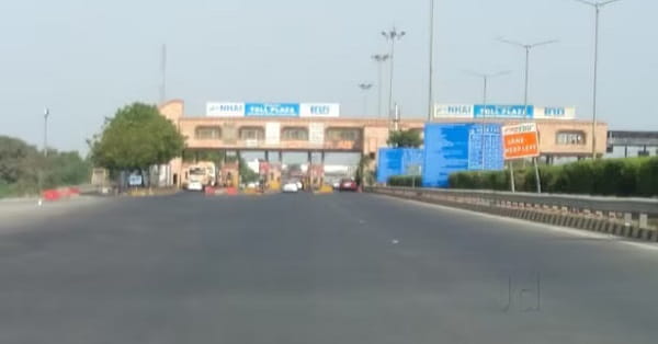
CTM Expressway Overview
| Detail | Information |
| Name | CTM Expressway (Narol-Naroda Road Corridor) |
| Full Form of CTM | Calico Textile Mill |
| Location | Hatkeshwar / CTM, East Ahmedabad, Gujarat — 380026 |
| Address Reference | 3/4, Narol-Naroda Road, Haridarshan Park, Laxmi Narayan Society, Hatkeshwar, Ahmedabad |
| Operated By | Part of Ahmedabad city road network |
| Key Road | Narol-Naroda Road |
| Connects To | Ahmedabad-Vadodara Expressway (NH-48); Sardar Patel Ring Road |
| AMTS Routes | Route 12D (CTM Cross Road–Chandkheda Gam; CTM Cross Roads–RTO Circle) |
| Nearest Metro Station | Rabari Colony — Ahmedabad Metro Line 1 (East-West Corridor) — Approx. 2 km |
| Metro Line | Connects to Apparel Park, Vastral Gam stations |
| Nearest Railway Station | Maninagar Railway Station — Approx. 3 km via Hatkeshwar Road |
| Nearest Airport | Sardar Vallabhbhai Patel International Airport — Approx. 15–18 km |
| Industrial Zones | Naroda Industrial Estate, Hatkeshwar GIDC |
| Zone Character | Industrial, residential, affordable housing mix |
Location
The CTM Expressway corridor is in eastern Ahmedabad’s Hatkeshwar zone — the industrial-residential interface that characterises the eastern city belt. The Narol-Naroda Road runs northward through the zone, connecting the southern industrial estate of Narol toward the northern Naroda industrial township, with CTM’s residential societies and commercial strips along the route.
Directions
From Ahmedabad Junction (Kalupur), travel eastward approximately 8 to 10 kilometres via the city arterials toward the Hatkeshwar-CTM zone, 20 to 30 minutes by AMTS or auto-rickshaw. From the Ahmedabad-Vadodara Expressway, take the Narol exit and travel northward through the Narol-Naroda Road corridor toward CTM. From Rabari Colony Metro Station, the CTM zone is within 2 kilometres by auto-rickshaw.
Connectivity
Ahmedabad Metro Line 1 at Rabari Colony provides east-west metro connectivity toward Apparel Park, Vastral Gam, and westward to the BRTS and commercial zones of central Ahmedabad. The Ahmedabad-Vadodara Expressway at Narol gives the CTM corridor direct highway access to Vadodara. The Sardar Patel Ring Road — Ahmedabad’s 76-kilometre ring road that crosses Narol as a toll point — encircles the city and is accessible from the CTM corridor at multiple junction points.
Nearby Areas
Naroda Industrial Township — one of Ahmedabad’s most extensive manufacturing and industrial zones — is the primary economic driver for the CTM expressway corridor’s daily traffic. The Vastral residential zone developing rapidly along the metro Line 1 corridor is an emerging residential address accessible from CTM. The Isanpur and Khokhra commercial belt are within the broader eastern Ahmedabad zone served by this arterial.
Frequently Asked Questions (FAQs)
Q1. What does CTM stand for in CTM Expressway, Ahmedabad?
A: Calico Textile Mill — the historic textile mill that gave the eastern Ahmedabad neighborhood its enduring name and abbreviation.
Q2. Which highway does the CTM Expressway corridor connect to?
A: The Narol-Naroda Road connects directly toward the Ahmedabad-Vadodara Expressway (NH-48) and the Sardar Patel Ring Road.
Q3. Which metro station serves the CTM Expressway area?
A: Rabari Colony Station on Ahmedabad Metro Line 1 (East-West Corridor) — approximately 2 km from CTM, connecting to Apparel Park and Vastral Gam.
Q4. Which AMTS bus routes serve CTM Cross Road?
A: Route 12D runs from CTM Cross Road to Chandkheda Gam and CTM Cross Roads to RTO Circle.
Q5. Which industrial zone is near CTM Expressway?
A: Naroda Industrial Estate and Hatkeshwar GIDC — two of Ahmedabad’s most significant manufacturing and industrial concentrations — are in the immediate CTM corridor catchment.