India’s canal infrastructure from the colonial era was designed to carry water. The Upper Ganga Canal — excavated between 1842 and 1854 under the oversight of British engineer Proby Cautley — draws water from the Ganga at Haridwar and carries it 570 kilometres southward through the Doab to irrigate the fields of western Uttar Pradesh. It is one of the oldest and most extensive artificial waterways in Asia, and its straight-line geometry through flat agricultural land makes it a natural template for a parallel expressway.
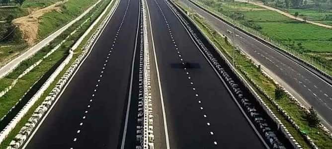
The Upper Ganga Canal Expressway, also known as the Hindon Expressway in its earlier planning iterations, is an 8-lane, 147.8-kilometre access-controlled expressway running parallel to the Upper Ganga Canal from Sanauta Bridge in Bulandshahr to Pukhrazi in Muzaffarnagar. UPEIDA originally proposed this corridor under the name Hindon Expressway along the Hindon River; the route was changed in 2009 by the UP government to follow the Upper Ganga Canal instead, shortening it by 80 kilometres. Construction was then delayed for 11 years due to land acquisition disputes and planning revisions — a record that gave the project its reputation as UP’s most complicated expressway gestation.
In 2025, construction resumed with renewed momentum — UPEIDA restarted civil works and YEIDA confirmed a November 2025 completion target. The project budget stands at approximately ₹8,700 crore and includes not just the main 147.8-kilometre 8-lane expressway but also a 68.5-kilometre, 6-lane link expressway and a 97.3-kilometre, 2-lane service road. Seven hydroelectric power stations are planned at canal falls along the route to generate power for the expressway’s operations — an energy-self-sufficiency feature unique among Indian expressways. Water sports and tourism facilities are also planned at three canal fall locations, making this a leisure infrastructure project as much as a transport corridor.
As a Ganga Expressway Phase-2 spur, the Upper Ganga Canal Expressway extends the Ganga Expressway’s Meerut-Bulandshahr section northwestward into Muzaffarnagar and eventually to Haridwar — the pilgrimage city at the foot of the Himalayas.
| Detail | Information |
| Name | Upper Ganga Canal Expressway / Hindon Expressway (former name) |
| Maintained By | UPEIDA |
| Length | 147.8 km (main expressway) |
| Link Expressway | 68.5 km (6-lane) |
| Service Road | 97.3 km (2-lane) |
| Lanes | 8-lane (main) |
| West/South End | Sanauta Bridge, Bulandshahr |
| East/North End | Pukhrazi, Muzaffarnagar |
| Budget | ₹8,700 crore |
| Construction Resume | 2025 |
| Target Completion | November 2025 (revised; actual operational status to be confirmed) |
| Ganga Expressway Link | Spur-1 of Ganga Expressway Phase 2 (approved January 2025) |
| Phase-2 Extension | 110 km spur from Bulandshahr–Meerut junction to Haridwar |
| Districts Covered | Gautam Buddha Nagar, Bulandshahr, Meerut, Ghaziabad, Muzaffarnagar, Saharanpur |
| States | Uttar Pradesh (Uttarakhand portion via Haridwar extension) |
| Unique Feature 1 | 7 hydroelectric power stations at canal falls — self-powered expressway |
| Unique Feature 2 | Water sports and tourism at 3 canal fall locations |
| Land Parcels | 6 land development parcels along the route |
Route and Location
The expressway runs from Sanauta Bridge in Bulandshahr northwestward through Hapur, Ghaziabad, Meerut, and Muzaffarnagar — the western UP industrial and agricultural belt along the Ganga-Yamuna Doab. The alignment tracks the Upper Ganga Canal’s course as closely as land acquisition permits, creating a parallel infrastructure corridor beside one of South Asia’s oldest water engineering achievements. The canal’s embankments and the expressway’s access-controlled carriageways occupy adjacent strips of the same geographic corridor.
Connectivity
The Upper Ganga Canal Expressway connects at its southern end to the Ganga Expressway near Bulandshahr, giving Meerut and NCR travelers a direct onward route to Prayagraj. At its northern end it is planned to extend 110 kilometres further to Haridwar — connecting the expressway to the Char Dham Highway and the Delhi-Dehradun Expressway’s Haridwar Spur (50.7 km). When fully developed, the chain will give Delhi NCR pilgrims the fastest possible road route to Haridwar without entering any urban congestion.
Nearby Areas
Muzaffarnagar — the sugar industry capital of western UP, whose vast sugarcane farms and sugar mills define the regional economy — anchors the expressway’s northern end. Meerut, at the expressway’s middle section, is a major UP commercial and educational city with a rich Mutiny of 1857 heritage. Haridwar — India’s most important Hindu pilgrimage entry city for the Ganga — is the spiritual destination toward which the expressway’s northern extension ultimately points.
Frequently Asked Questions (FAQs)
Q1. What is the Upper Ganga Canal Expressway?
A: An 8-lane, 147.8-km expressway from Sanauta Bridge (Bulandshahr) to Pukhrazi (Muzaffarnagar) running parallel to the Upper Ganga Canal. Part of Ganga Expressway Phase-2; budget ₹8,700 crore.
Q2. Why was the Upper Ganga Canal Expressway delayed for 11 years?
A: Originally planned as Hindon Expressway along the Hindon River, the route was changed in 2009 to follow the Upper Ganga Canal — triggering fresh land acquisition disputes and planning revisions that stalled construction until 2025.
Q3. What makes the Upper Ganga Canal Expressway unique?
A: Seven hydroelectric power stations at canal falls will power the expressway’s operations — making it energy self-sufficient. Water sports tourism at three canal fall locations is also planned.
Q4. How does the Upper Ganga Canal Expressway connect to Haridwar?
A: A 110-km spur under Ganga Expressway Phase-2 (approved January 2025) will extend the expressway from Bulandshahr/Meerut northward to Haridwar, connecting to the Char Dham Highway.
Q5. Which phase of the Ganga Expressway is this?
A: Spur-1 of Ganga Expressway Phase-2 (approved January 2025) — combined with Spur-2 (Prayagraj-Ballia, 314 km), Phase-2 adds 455 km to the Ganga Expressway network.