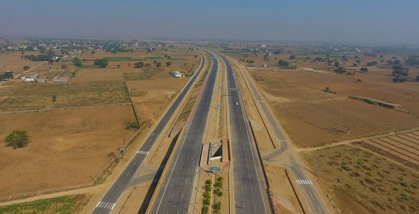
Eastern India’s connectivity deficit has been one of India’s most discussed infrastructure problems for decades. The states of Jharkhand and Bihar — between the gangetic plains of Uttar Pradesh and the Bengal delta — have some of the country’s lowest road quality indices relative to their economic potential. The Varanasi-Kolkata Expressway, officially the Varanasi-Ranchi-Kolkata Expressway on NH-319B, is the most ambitious single infrastructure response to this deficit — a 710-kilometre, six-lane greenfield corridor connecting two of India’s most historically and economically significant cities through the Jharkhand plateau and the mineral-rich tribal belt that has for too long been isolated from high-speed road connectivity.
The Varanasi-Ranchi-Kolkata Expressway on NH-319B is a 710-kilometre project currently under construction, with an expected opening in 2027. It begins at Revasa in Chandauli district, Uttar Pradesh, and ends at Sarisha near Diamond Harbour in West Bengal via an extended route including a Vertical Lift Bridge on the Hooghly River. The corridor passes through major cities including Varanasi, Chandauli, Bhabua, Sasaram, Aurangabad, Gaya, Chatra, Hazaribagh, Ramgarh, Ranchi, Bokaro, Purulia, Bankura, Bishnupur, Panskura, and Haldia — essentially threading together the industrial, mining, pilgrimage, and agricultural towns of one of India’s most geographically varied multi-state corridors. The expressway will cover 323 kilometres within West Bengal alone.
The strategic significance extends beyond travel time reduction. The Jharkhand plateau — Ranchi, Bokaro, Hazaribagh, Chatra — contains some of India’s richest mineral deposits, but the poor road connectivity has constrained logistics costs and limited the economic integration of this mineral belt with the consumption centers of eastern India. A six-lane greenfield expressway connecting the mineral economy of Jharkhand to the port economy of Haldia and the commercial economy of Kolkata changes that fundamental calculus.
| Detail | Information |
| Official Name | Varanasi–Ranchi–Kolkata Expressway |
| Highway Number | NH-319B |
| Maintained By | National Highways Authority of India (NHAI) |
| Length | 710 km |
| Lanes | 6-lane access-controlled |
| From (West End) | Revasa, Chandauli District, Uttar Pradesh |
| To (East End) | Sarisha, near Diamond Harbour, West Bengal |
| Expected Opening | 2027 |
| Current Status | Under construction |
| States Covered | Uttar Pradesh, Bihar, Jharkhand, West Bengal |
| Length in West Bengal | 323 km |
| Key Cities | Varanasi, Gaya, Ranchi, Bokaro, Purulia, Bankura, Bishnupur, Panskura, Haldia, Kolkata |
| Special Feature | Vertical Lift Bridge on Hooghly River (Diamond Harbour approach) |
| Land Acquisition Start | January 2022 (Tilouthu–Imamganj section, Bihar, 80 km) |
| Port Connectivity | Connects to Haldia Port, West Bengal — major petrochemical and cargo port |
Route and Location
The expressway begins at Chandauli district — where it picks up the traffic coming off the Varanasi urban zone — and heads eastward through Bihar’s mineral and agricultural plain via Sasaram, Aurangabad, and Gaya before climbing into the Jharkhand plateau through Chatra and Hazaribagh to Ranchi, the state capital. From Ranchi it descends through Bokaro and enters West Bengal through Purulia and Bankura — the red laterite landscape of the Chota Nagpur plateau giving way to the deltaic lowlands of Bengal before reaching Haldia Port and the Diamond Harbour spur near Kolkata.
Connectivity
The expressway will link directly to Haldia Port — one of India’s most important petroleum and bulk cargo ports — creating a critical road-to-port logistics corridor for eastern India. At Varanasi it connects to the existing NH-19 and the Purvanchal Expressway network of Uttar Pradesh. At Ranchi it will transform the connectivity of Jharkhand’s mineral and coal economy. The Vertical Lift Bridge over the Hooghly River near Diamond Harbour is among the expressway’s most engineering-ambitious elements.
Nearby Areas
Gaya and Bodh Gaya: The Buddhist pilgrimage city where the Buddha attained enlightenment under the Bodhi Tree is directly accessible from the expressway’s Bihar section — Gaya is one of India’s most internationally visited pilgrimage destinations and a UNESCO World Heritage Site candidate. Hazaribagh: The plateau town with its tiger reserve and pleasant climate is one of Jharkhand’s primary leisure destinations accessible from the expressway corridor. Bishnupur: West Bengal’s extraordinary terracotta temple town of the Malla kings — whose brick temples with intricate terracotta panels represent a unique tradition of religious architecture — is on the expressway’s West Bengal section.
Frequently Asked Questions (FAQs)
Q1. What is the Varanasi Kolkata Expressway?
A: NH-319B, a 710 km six-lane greenfield expressway connecting Varanasi (Chandauli) to Kolkata (Diamond Harbour) via Ranchi. Under construction, expected 2027.
Q2. Which states does the Varanasi Kolkata Expressway pass through?
A: Four — Uttar Pradesh, Bihar, Jharkhand, and West Bengal. West Bengal alone accounts for 323 km of the total length.
Q3. What is special about the eastern end of the Varanasi Kolkata Expressway?
A: A Vertical Lift Bridge over the Hooghly River near Diamond Harbour — one of the expressway’s major engineering features — connects the corridor to Sarisha in West Bengal.
Q4. Which major city is at the expressway’s midpoint?
A: Ranchi — the Jharkhand state capital — is the geographic and economic midpoint, giving the state its first high-speed expressway connection to both UP and Kolkata.
Q5. When is the Varanasi Kolkata Expressway expected to open?
A: 2027, per NHAI’s project timeline. Land acquisition in Bihar began in January 2022 on the Tilouthu-Imamganj section.